The Charleston Agent’s Guide to Drone and Aerial Real Estate Photography
The Charleston real estate market sells land and water as much as it sells square footage. A marsh-back lot on Johns Island, a deep-water dock on the Wando River, a golf course view in Daniel Island: these are listing features that ground-level photography cannot communicate. Drone real estate photography in Charleston SC gives listing agents a tool that works especially hard in this market, where location and lifestyle drive buyer decisions in ways that interior shots and street-level exteriors simply cannot capture.
Aerial photography for real estate has moved from a premium add-on to a mainstream tool. According to the National Association of REALTORS 2025 Technology Survey, 52% of agents now use drone photography and video in their listings, making it the third most-used technology in real estate marketing behind eSignature and social media. In the Lowcountry, where waterfront access, marsh views, and community context routinely determine list price and buyer interest, that adoption rate reflects something agents here already know: for the right listing, aerial coverage is not optional.
What Aerial Photography Does That Ground Photos Cannot
Standard real estate photography is bounded by eye level. A skilled photographer working from the ground captures interiors, curb appeal, and exterior detail. What ground-level photography cannot do is frame context: the relationship between a property and its surroundings, the scale of a lot, the features of a backyard, or the view from well above what any tripod can reach. A professional tripod maxes out at 7 to 8 feet. Everything above that is territory only a drone can cover.
Drone and aerial photography fills that gap in several ways that matter specifically to agents working the Charleston market.
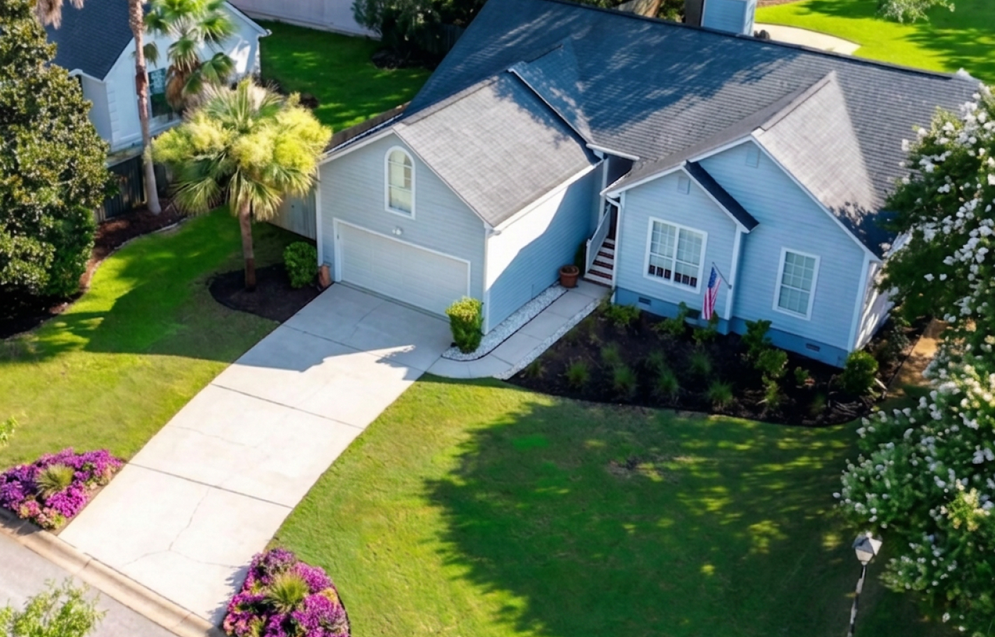
Lot and land context. On large lots, acreage, and waterfront properties, ground photography communicates almost nothing about the land itself. An aerial shot shows lot boundaries, setbacks, tree coverage, and the relationship between structures and available land in a single frame. For buyers evaluating a Johns Island property with several acres or a lot on Wadmalaw, that context is the listing.
Water access and waterfront features. Dock access, creek frontage, Intracoastal proximity, and marsh views are among the highest-value features in the Lowcountry market. None of them read clearly from the ground. A drone at altitude shows the dock, the water, the depth of the marsh behind the property, and the relationship between the home and the water in a way that drives buyer interest before a showing is ever scheduled.
Backyard and outdoor living spaces. A pool, an outdoor kitchen, a screened porch with a unique layout, a detached garage or workshop: these features read completely differently from above than from ground level. Aerial angles show the full scope of an outdoor living setup in a single image that no ground shot can match.
Roofline and upper exterior detail. At 50 to 80 feet above ground, a drone captures roofline condition, upper exterior detail, gutters, and architectural features that no ground shot reaches cleanly. For agents representing properties where exterior condition or roofline character is a selling point, aerial coverage closes a gap that standard photography leaves open.
Neighborhood and community context. For new construction communities in Summerville, Cane Bay, and Nexton, proximity to amenities is part of the value proposition. At 100 to 200 feet, aerial photography shows community pools, walking trails, nearby schools, and neighborhood character in ways that interior photos never address. For buyers relocating from out of market, those contextual images often carry more weight than anything inside the home. At 200 to 300 feet, large acreage, waterfront properties, and golf course listings open up into wide landscape frames that show scale and setting as the story.
Why the Lowcountry Market Makes Drone Photography Worth Adding
Not every market places the same weight on aerial photography. The Lowcountry does, for reasons that come directly from the character of the land and the buyer pool.
Charleston buyers, and especially buyers relocating from out of market, are making decisions about a lifestyle as much as a floor plan. They are looking at waterfront access, marsh views, barrier island proximity, community character, and the Lowcountry aesthetic that makes this market distinct from every other coastal market on the East Coast. Aerial photography communicates all of that in ways that no interior image can.
The property types where drone and aerial photography consistently earns its place in this market include waterfront and dock properties on the Intracoastal, Ashley, Cooper, and Wando Rivers, where water access is the primary value driver. Tidal marsh-back lots on James Island, Johns Island, and Wadmalaw, where the marsh itself is the view. Large acreage and rural properties where lot size and land character are the story. Golf course and club communities including Daniel Island, Kiawah, and Seabrook, where the view from the backyard justifies the price point. Luxury listings in Mount Pleasant, Isle of Palms, Sullivan’s Island, and South of Broad, where aerial coverage is a presentation standard buyers expect at that price tier. New construction neighborhoods in Summerville, Cane Bay, and Nexton, where community context and proximity to amenities matter to buyers evaluating competing developments.
Beyond these obvious cases, aerial photography also adds value on standard residential listings where the exterior, backyard, or lot has a story to tell that ground photography cannot frame. A well-landscaped corner lot, a rear addition with a patio and pool setup, a property with mature tree canopy: these details read differently from above.
FAA Licensing and Why It Matters for Your Listing
Every drone flight conducted in connection with a real estate listing is classified by the FAA as a commercial operation. That classification is based on the purpose of the flight, not whether the pilot is separately paid for the drone work. If a drone captures images that will be used to market a property for sale, the flight is commercial. Full stop.
Commercial drone operation requires FAA Part 107 certification: a federal license obtained by passing an aeronautical knowledge exam, completing TSA vetting, and completing recurrent training every 24 months. Every drone used commercially must be registered with the FAA and broadcast Remote ID during flight.
Operating without that certification carries civil penalties up to $75,000 per violation under the FAA Reauthorization Act of 2024. The FAA updated its enforcement policy in 2026 to make legal action the default response when drone operations violate airspace restrictions or endanger the public. Beyond the penalty exposure, unlicensed operators cannot obtain commercial drone insurance. That insurance gap is the more immediate concern for listing agents: if an unlicensed, uninsured operator causes property damage, injures someone near the listing, or generates a privacy claim from inadvertently capturing a neighboring property, there is no coverage in place. The recovery chain in those scenarios runs through the listing agent and their brokerage.
Booking a licensed, insured drone operator removes that exposure. For agents whose brokerages require a Certificate of Insurance before approving aerial work on a listing, a COI from a Part 107 certified operator with commercial liability coverage satisfies that requirement directly.
For a deeper look at what FAA licensing means for agents vetting drone photographers, see our guide to hiring an FAA licensed drone photographer for real estate in Charleston.
What to Expect From a Drone Real Estate Photography Shoot
A professional aerial shoot for a Charleston listing follows a predictable workflow that agents can plan around.
Pre-shoot airspace check and day-of verification. Parts of the Charleston metro area fall within controlled airspace tied to Charleston International Airport and Joint Base Charleston. Flights in those zones require airspace authorization before any flight can legally take place. Depending on the location and altitude, that authorization can often be confirmed in near-real-time through the FAA’s automated authorization system. In other cases, advance coordination is needed. Either way, authorization is handled before the shoot.
Beyond standing airspace, conditions can change between booking and shoot day. Temporary Flight Restrictions can be issued with little notice for emergency operations, military exercises, or other events that affect the airspace over a specific area. Part of operating professionally is checking for active TFRs, airspace NOTAMs, and any restrictions that may have been issued for that specific date and time, not just at the time of booking. That day-of check is a standard step on every shoot.
Drones are also prohibited over city park facilities and Charleston County park and recreation areas, which include James Island County Park, Folly Beach County Park, Isle of Palms County Park, and others. For listings near those locations, the launch point and flight path are planned accordingly.
Weather monitoring and cloud clearance. Drone operations are more weather-sensitive than interior shoots. Part 107 requires minimum flight visibility of 3 statute miles and specific cloud clearance: at least 500 feet below clouds and 2,000 feet horizontally from clouds. In practice this means an overcast or low-cloud morning that looks flyable from the ground may not meet legal flight requirements. Wind, rain, and active storm systems ground flights entirely.
Weather conditions are monitored in the days and hours leading up to every shoot. If conditions on the day make flying unsafe or non-compliant, the drone portion is rescheduled at no cost. For days where the sky is the only issue but flight conditions otherwise meet requirements, blue sky replacement is available as an editing option and can be applied during post-processing.
Shoot day. The agent does not need to be on-site. Access to the property needs to be arranged in advance, whether that is a lockbox code, a gate code, or any other access requirement. The drone shoot itself is a focused aerial session that works efficiently alongside or separately from the interior photo shoot.
Delivery. Drone and aerial images are delivered in the standard next-day window. Agents receive a download link within 24 hours of the shoot.
Drone Photography Pricing for Charleston Listings
Drone and aerial photography is available at price points that fit different listing needs. Add aerial coverage to a Standard or Large Shoot as a bundle, book a Standalone Drone Session for listings where aerial is the priority, or add drone to other services with the Drone Add-On option.
For a full breakdown of what drone photography costs in the Charleston market, including what agents typically pay across providers and how to evaluate pricing, see our guide to drone real estate photography cost in Charleston.
For current pricing on all drone packages and add-ons, visit the drone photography service page.
Adding Drone Coverage to Your Charleston Listings
Aerial and drone real estate photography in Charleston SC is available for waterfront, marsh, large lot, golf course, luxury, and standard residential listings across the Lowcountry. Every shoot is flown under FAA Part 107 commercial license, fully insured, with next-day delivery as standard.
If a property has land, water, or location as part of its story, aerial photography makes that case better than anything else in the listing package.
Book a drone shoot or add aerial coverage to an upcoming listing: 843-790-2820 | Book online